


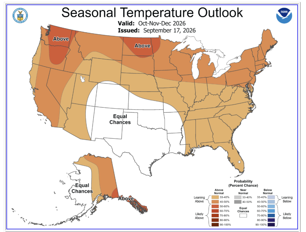
Bad news for snuggly sweaters, but good news for the cute skirts we wear them with: fall is expected to be warmer than average in NYC this year.
According to the National Weather Service, New Yorkers can expect above–average temperatures to carry into the season, with winter potentially following suit. Rainfall should be roughly average through October, while precipitation could pick up later in the fall and into winter. And while warmer temperatures could mean fewer snowy days overall, that certainly doesn’t mean NYC is completely off the hook for a major snowstorm.
The forecast comes as fall officially begins with the equinox on September 22, when day and night are roughly equal in length. From there, the days will gradually get shorter and the nights longer—by the end of September, sunset will be nearly an hour earlier than it was at the start of the month.
So, whether you’re ready to break out the fall wardrobe or stubbornly holding onto summer for as long as possible, here’s what the National Weather Service is predicting for NYC’s fall and winter—and what it could mean for everything from sweaters to snow days.
What Does the National Weather Service Say About NYC’s Fall Forecast?
The National Weather Service projects a warmer–than–average autumn across the tri-state area. However, temperature is only one part of the story:
- Rainfall Outlook: October is slated for near-average precipitation levels. However, moisture is expected to pick up significantly in late fall, setting up a wetter-than-normal transition into winter.
- Hurricane Season Watch: While the Atlantic hurricane season is projected to remain relatively quiet through the rest of the year, meteorologists warn that late-season tropical systems in October cannot be entirely ruled out.
The Main Climate Driver: How El Niño Will Shape Winter and Snowfall
The primary engine behind this year’s unusual weather pattern is a “very strong” El Niño event developing in the Pacific Ocean. El Niño typically shifts the jet stream, driving warmer air into the northern United States while bringing increased moisture across the coastal east.
What does this mean for snow in NYC?
- Fewer Snow Days Overall: Higher baseline temperatures mean more late-fall and winter storms will result in cold rain rather than accumulated snow.
- Nor’easter Potential: Warmer average temperatures do not rule out a major snowstorm. A powerful, well-timed arctic blast hitting an moisture-rich El Niño pattern can still create an intense, heavy snowfall event.

How Does This Differ From Last Year?
Unlike last year’s colder snaps and erratic dry spells, this season is being hijacked by a “very strong” El Niño. That means higher baseline temperatures, significantly more moisture pushing up the coast, and a much higher chance that mid-winter storms end up as slushy rain instead of crisp snowfall.