

With the last few weeks of summer upon us, we have a bit of a hunch that winter weather is the last thing on New Yorkers’ minds. But, as always, Mother Nature doesn’t wait until we’re ready—especially here on the East Coast.
Case in point: a rare and unusually powerful Super El Niño is brewing, and its potential impact on the months ahead has suddenly made fall and winter weather a very relevant topic, even in these final days of August.
The weather phenomenon, which is forecast to strengthen rapidly in the coming months, could have major implications for the Northeast, potentially bringing warmer–than–average temperatures and less snow this fall and winter. And with some forecasts suggesting it has a nearly 70% chance of becoming the strongest El Niño on record by the end of the year, this is far from your average seasonal weather pattern.
From its official emergence to the latest winter forecasts, here is a complete look at what this climate phenomenon is, how it has developed, and what it means for your winter plans.

🧪 What Is a Super El Niño?
Let’s start with a little science lesson, shall we?
According to the NOAA, El Niño (Spanish for “little boy”) is a natural climate pattern marked by a prolonged period of above-average sea surface temperatures across the equatorial Pacific Ocean. Under normal conditions, trade winds blow strongly from east to west, pushing warm surface water toward Asia and allowing cooler, nutrient-dense water to rise along the South American coast.
During El Niño, those trade winds weaken or even reverse. Warm water sloshes back toward the Americas, disrupting global weather patterns by shifting the Pacific jet stream south.
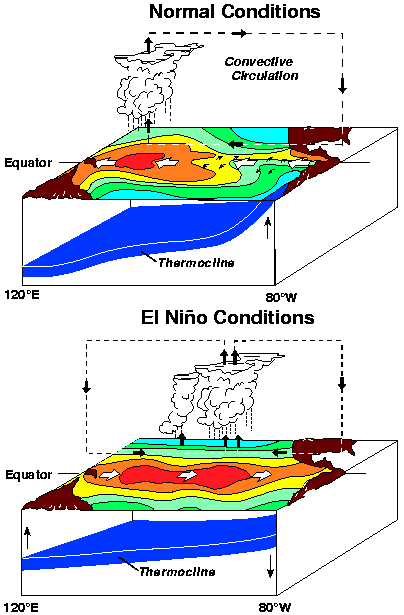
- The Baseline Threshold: According to the NOAA, an El Niño officially forms when eastern Pacific ocean temperatures rise at least 0.5°C above average for several consecutive months, accompanied by a breakdown in the Walker Circulation (the atmospheric air loop driven by oceanic temperature differences).
- The “Super” Upgrade: While standard El Niño events happen every few years, a Super El Niño occurs when ocean temperatures spike 2.0°C (3.6°F) or more above historical averages.
- A “Once-in-a-Lifetime” Event: According to NOAA meteorologist Nat Johnson in statements to CNN Weather, this rapidly intensifying pattern is “something that’s very unusual, if not a once-in-a-lifetime type of strength.”
🗓️ From June to Now: How the 2026 El Niño Has Developed
The path to this potential record-breaker started early in the year and accelerated over the summer months:
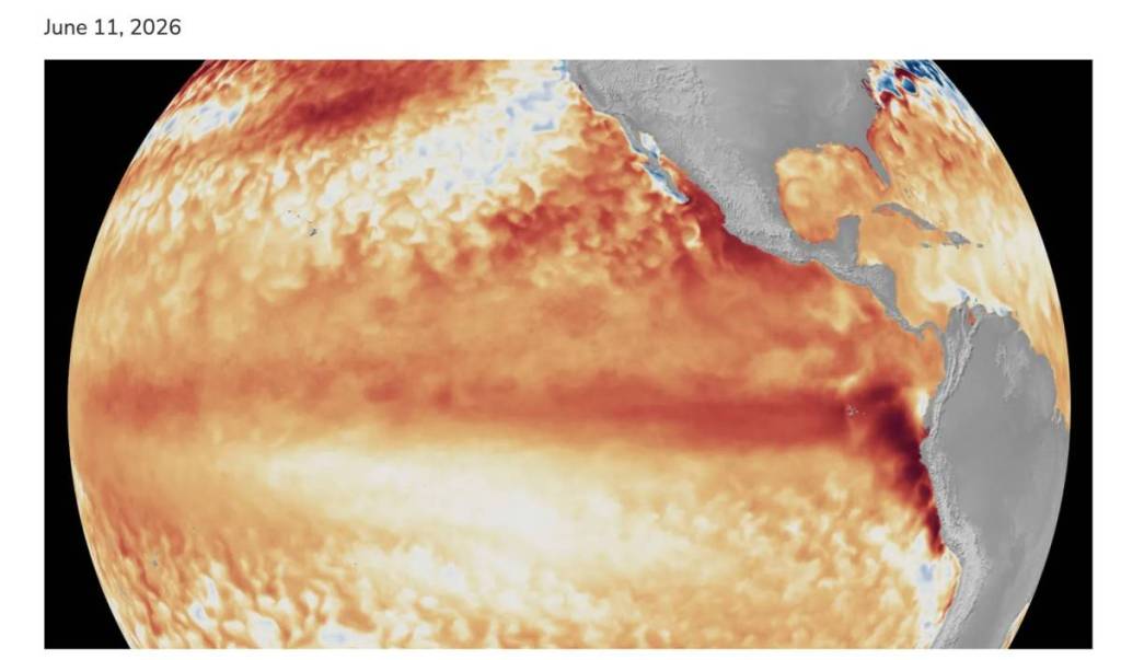
- June: El Niño officially arrives: NOAA issued an El Niño Advisory on June 11 after unusually warm waters developed in the tropical Pacific. Early forecasts gave the event a 63% chance of becoming “very strong” by winter.
- Summer—The warming accelerates: As the summer went on, Pacific Ocean temperatures rose at an unusually rapid pace. By late August, forecasters were warning that this El Niño could become one of the strongest on record.
- Now—A historic event is possible: Forecasts cited by AccuWeather show more than a 90% chance of a “very strong” El Niño developing this fall and winter. There is also a 69% chance it could become a historic event stronger than any El Niño recorded since 1950.
🗽 Will New York and the Northeast Experience It This Year?
The short answer is yes, the atmospheric chain reaction will reach the East Coast—and newly updated official data shows it could be one of the most intense events on record. NOAA’s Climate Prediction Center now puts the odds of a very strong El Niño lasting through winter 2026–27 at more than 90%, with a 69% chance it could become one of the strongest events on record. Here’s what to expect in our favorite state:
- Warmer temperatures: NOAA forecasts favor above-average temperatures across much of the northern U.S., including New York. That could mean fewer prolonged deep freezes and Arctic cold snaps.
- More rain, less snow: A stronger El Niño can bring more moisture to the East Coast, but milder temperatures mean storms that might normally produce snow could instead bring rain, sleet, or slush.
- Greater coastal flooding risk: Powerful El Niño patterns can also fuel stormier conditions along the East Coast, increasing the risk of high-tide flooding and beach erosion during winter storms.
That said, a strong El Niño doesn’t mean NYC won’t see snow at all. A well-timed blast of cold air could still bring significant snowfall. But overall, the early outlook suggests New Yorkers may want to keep the rain boots handy—this winter could be wetter and warmer than snowy.
☃️ Less Snow This Winter?
For snow lovers hoping for winter sledding in Central Park, a Super El Niño is usually bad news.
- Rain Over Powder: Because temperatures along the East Coast are projected to hover above freezing during major precipitation events, much of what would typically fall as snow is expected to land as rain, sleet, or slush.
- Long-Term Trends: Climate research adds another layer: according to data from Climate Central, annual snowfall amounts have dropped in nearly two-thirds of the U.S. since 1970 due to a warming climate. Combined with an active El Niño, the odds of a blanketed “winter wonderland” shrink significantly.
- Exception to the Rule: An occasional fluke storm is still possible if a rare blast of polar air collides with southern moisture—potentially around late November—but sustained snowpack throughout the season is unlikely.
If there is one thing New Yorkers know how to do, it is adapt. Sure, a Super El Niño taking the reins means your dreams of a picturesque, blanketed Central Park might turn into a lukewarm reality of slush, rain, and extra-soggy subway steps.
But on the bright side? You can probably leave that heavy–duty snow shovel buried deep in the back of your closet for another year, and your heating bill might not send you into complete shock.
Mother Nature might be dialing up a wild, wet, and mild winter—but at least we won’t have to scrape an inch of ice off our windshields every morning!
🔗 For more information on the brewing Super El Niño, see the official NOAA page.