
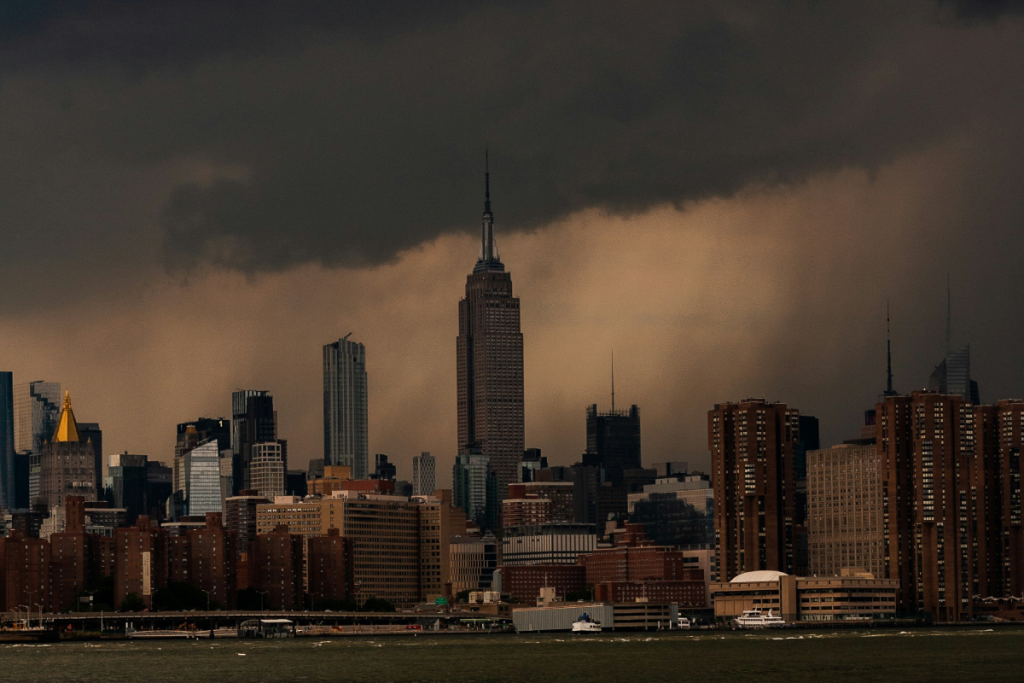

For New Yorkers with access to a nearby window, this weekend’s weather forecast probably won’t come as much of a surprise. Well, maybe it will — particularly if you aren’t used to seeing phrases like tornado warning and quarter-sized hail pop up in your local weather updates.
The National Weather Service has issued a tornado warning for Queens County until 2 p.m. Thursday, November 12, as a powerful storm system moves through the Tri-State area. A tornado watch is also in effect for parts of New Jersey until 7 p.m., while a Special Marine Warning covers New York Harbor and coastal waters stretching from Sandy Hook, New Jersey, to Fire Island Inlet, Long Island, until 1:45 p.m.
And that’s not all the weather has in store. Forecasters are tracking heavy rainfall, potentially severe thunderstorms, gusty winds and localized flooding throughout the afternoon and evening. Some areas could see more than two inches of rain, particularly where heavier downpours repeatedly move over the same communities.
Thursday’s relatively mild temperatures are also about to make a dramatic exit. Behind the storm system, much colder air will sweep into the region, bringing Friday temperatures down into the 40s, with gusty winds making it feel even colder. In other words, those lighter jackets might be getting a very short-lived encore.
Here’s what New Yorkers should know about the latest weather alerts, what to expect across the five boroughs and the Tri-State area, and when conditions are expected to improve.
What the NWS is predicting for this weekend
If you had outdoor brunch plans, you might want to pivot to a cozy booth indoors—and pack a heavier coat while you’re at it. The storm system isn’t expected to evolve into a full-fledged nor’easter, so you can hold off on panic-buying bread and milk, though it is bringing the coldest air of the season right behind it.
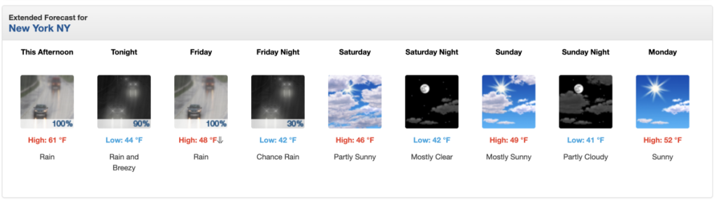
- Thursday afternoon and evening: Rain is locked in at a 100% chance, with temperatures hovering near 61°F before the front sweeps through. Expect up to three-quarters of an inch of rain during the afternoon, followed by another quarter to half-inch tonight as north winds pick up to 14–20 mph.
- Friday: Prepare for a rude awakening. Temperatures will peak early around 48°F before tumbling to about 43°F by 10 a.m., with gusty north winds making it feel closer to the low-to-mid 30s. Rain will stick around through the day before finally tapering off late Friday night.
- Meanwhile, higher elevations in the Catskills and Poconos above 1,500 feet are looking at 1 to 3 inches of snow—and up to 5 inches in parts of northern Ulster County.
- Saturday and Sunday: The rain finally clocks out, leaving behind brisk, autumn-certified sunshine. Saturday will be partly sunny and blustery with a high near 46°F, while Sunday warms up ever so slightly to a mostly sunny 49°F. Overnight lows will dip into the low 40s.
Wait…tornadoes and hail?
It sounds like a plot twist meant for the Midwest, not the 7 train, yet here we are. A fast-moving storm cell prompted the NWS to issue a Tornado Warning for Queens County until 2:00 p.m., alongside a Tornado Watch for central and southern New Jersey until 7:00 p.m. Forecasters also flagged a Special Marine Warning for New York Harbor and the waters from Sandy Hook to Fire Island Inlet until 1:45 p.m.
Why the sudden drama? Warm, muggy air clashing with a sharp cold front is fueling isolated thunderstorms capable of producing small hail, gusty winds, and brief spin-ups.
While the severe weather threat is highest south of the I-78 corridor in New Jersey (rated a Level 2 out of 5 risk), the five boroughs and Nassau County sit squarely in a Level 1 risk zone. Even if the nastiest storm cells stay just offshore or east of the city, lightning within 20 miles and sudden downpours dropping over an inch of rain per hour are very much on the table for the evening commute.
How to stay safe amidst extreme weather in NYC
Navigating extreme weather in a concrete jungle comes with its own quirks—mostly involving questionable subway drainage and rogue umbrellas. A few smart moves will keep you dry and out of harm’s way:
- Treat tornado warnings seriously: If you are in Queens or anywhere under a warning, move to an interior room on the lowest floor of a sturdy building—away from windows. Skip the urge to film the sky from your fire escape.
- Watch your step (and your route) during the commute: Slow-moving bands of rain can quickly overwhelm storm drains, leading to localized street flooding and ponding on highways. Never drive or walk through flooded underpasses or subway entrances, and check MTA service alerts before heading underground.
- Mind the coast at high tide: Minor coastal flooding is possible along the western Long Island Sound, southern Nassau County, and parts of the Jersey Shore around high tide. If you park near the water, consider moving your car to higher ground.
- Stay plugged into live alerts: Conditions can shift block by block. Keep an eye on local radar and sign up for Notify NYC (text NOTIFYNYC to 692-692) for real-time emergency updates straight to your phone.
Don’t miss out! Follow us on Facebook, Instagram, and now on WhatsApp, too!